


 ЧЪРкДхФФ ОпАЃЛѓДу ПРЧТ
 11ГтПЌМг МвКёРкИИСЗ 1РЇ
 ГЛАд ИТДТ ОюЧаПј УЃБт
 ИЎОѓ ЧаБГ ЙцЙЎБт
 СжИЛПЁ ГЛАЁ ОЕ КёПыРК?
 УжАэАЁМККё РЬКЅЦЎ СёБтБт
 ЧіСіПЁМЕЕ ЧЪРкДхФФ!
 ЧіСіПЁМ АЁДЩЧб


 ЧЪРк ЦЏБо Ч§ХУ! ФСНУОюСі МКёНК


 АЁСЗПЌМіЗЮ ДйЧдАд ОзЦМКёЦМ

-
МјРЇСІИёСЖШИМі
-
 И№ОЫ КИОЫ Йъ ЗЛЦЎЧЯБт~ ИЎСЖЦЎ ПЙОрБюСі
 88,249
 -
 [ЧЪИЎЧЩ ММКЮ] ФЋИ№ХзНК ПЉЧр 100Йш СёБтБт 39,003
 -
 ИЖДвЖѓ НУГЛ - ИЎРп АјПјСЄКИ. (ЛчСј 16Рх ЦїЧд) 30,160
 -
 ММКЮРЧ СіПЊСЄКИ15,156
 -
 ИЖДвЖѓ БйБГ - ЕћАЁРЬЕћРЬ ПЉЧр СЄКИ13,691
 -
 [ЧЪИЎЧЩ ММКЮ/ИЗХК] ШЃХк МїЙк ПфБн Йз СЄКИ12,693
 -
 КИЖѓФЋРЬРЧ И№Еч И№НРРЛ КММі РжДТ ЛчСјУИ.12,571
 -
 ИЖДвЖѓ БйБГ - ЦХЛѓЧб ЦјЦї ПЉЧрСЄКИ12,129
 -
 [ММКЮ-ЙшМБТјРх] МБЙкШИЛч РќШЙјШЃПЁПф~11,693
 -
 ИЖДвЖѓ СіПЊ(ПЁИЃЙЬХИ -ИЛЖѓХз)РЧ СіЕЕ/ЧбБЙ РННФСЁ/МюЧЮИє11,585


- РЬИЇ : jilo
- РлМКРЯ : 2011-09-21
- СЖШИМі : 2334
- УпУЕМі : 0
MAP
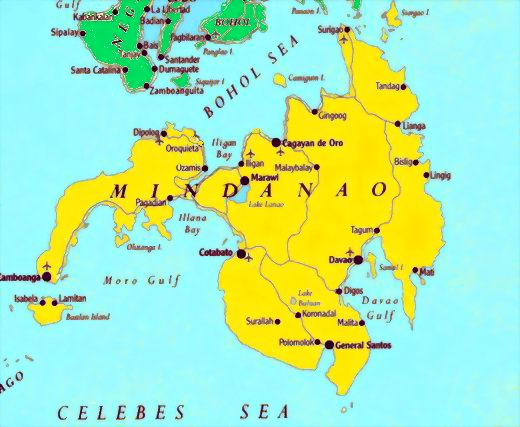
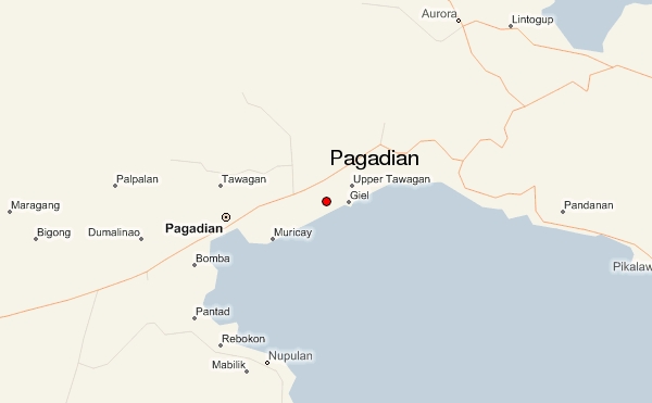
The City of Pagadian (Filipino: Lungsod ng Pagadian, Cebuano: Dakbayan sa Pagadian, Spanish/Chavacano:
Ciudad de Pagadian, Iranun: Bandar Eng'd a Pagadian, Subanen:Gembagel G'benwa P'hagadi-an/Bagbenwa P'hagadi-an) is located in the province of Zamboanga del Sur, in the island of Mindanao. It is the regional
government seat of Zamboanga Peninsula (Region 9) of the Republic of the Philippines.
The city started its humble beginnings as a stopover for traders who ply the road between the Spanish town-
fort of Zamboanga on the southern tip of the Zamboanga Peninsula and other bigger towns to the north of the
old province of Zamboanga. Apart from its sheltered bay and good fishing grounds, it was not a place where
anyone envisioned a city would be founded upon it, as it mostly consists of rolling terrain. In the course of its
local history, steady waves of different kinds of people settled into the place. Eventually these people came to
love the area's hilly features and called among themselves "Pagadianons."
Situated on the northeastern side of the Western Mindanao region, Pagadian is the capital city of Zamboanga
del Sur[7] province. It is bounded by the municipalities of Tigbao and Dumalinao on the southwest, Lakewood
on the west, Labangan on the east and northwest, and Midsalip on the north.
It is located within the tropics of the northern hemisphere which has pronounced dry season from January to
March and rainy season from April to December. The region is generally not affected by tropical storms and
typhoons as it is located outside the Philippine Typhoon Belt. Temperatures range from 22.2 ТАC (72.0 ТАF) to
32.9 ТАC (91.2 ТАF). The prevailing winds are the southwest wind that blow shot gust wind from over the sea
during dry seasons going northeast, and the trade winds brought about by the mountain range. Rainfall
distribution is moderate from 2,500 mm to 3,000 mm annually.


- ЁЄ
- ЁЄ
- ЁЄ
- ЁЄ
- ЁЄ
- ЁЄ
- ЁЄ
- ЁЄ
- ЁЄ
- ЁЄNmjNUuzXqd
- ЁЄNmjNUuzXqd
- ЁЄNmjNUuzXqd
- ЁЄNmjNUuzXqd
- ЁЄNmjNUuzXqd
- ЁЄNmjNUuzXqd


-
МПяМОХЭ :МПя АГВБИ ХзЧьЖѕЗЮ27Бц 8, 10Уў (ПЊЛяЕП, ПЅХИПі)02-3482-0542
-
УЛСжМОХЭ :УцКЯ УЛСжНУ ЛѓДчБИ ЛчСїДыЗЮ 350ЙјБц 11-2, 3Уў(МЙЎЕП)043-221-0543
-
КЮЛъМОХЭ :КЮЛъБЄПЊНУ КЮЛъСјБИ СпОгДыЗЮ 721-1, 5Уў(КЮРќЕП)051-808-0515
-
УЂПјМОХЭ :АцГВ УЂПјНУ МКЛъБИ ДмСЄЗЮ 9, 12Уў (ЛѓГВЕП, ХфХфНККєЕљ)055-282-9345


-
ЛчРЬЦЎ СЂМгРк ХыАш
-
ПРДУ212ОюСІ238
-
ЧбДо33,515ДЉРћ12,195,124
-
РЯРЯУжАэ94,672ШИПјМі20,299