


![]()


 ЧЪРкДхФФ ОпАЃЛѓДу ПРЧТ
 12ГтПЌМг МвКёРкИИСЗ 1РЇ
 ГЛАд ИТДТ ОюЧаПј УЃБт
 ИЎОѓ ЧаБГ ЙцЙЎБт
 СжИЛПЁ ГЛАЁ ОЕ КёПыРК?
 УжАэАЁМККё РЬКЅЦЎ СёБтБт
 ЧіСіПЁМЕЕ ЧЪРкДхФФ!
 ЧіСіПЁМ АЁДЩЧб


 ЧЪРк ЦЏБо Ч§ХУ! ФСНУОюСі МКёНК


-
МјРЇСІИёСЖШИМі
-
 И№ОЫ КИОЫ Йъ ЗЛЦЎЧЯБт~ ИЎСЖЦЎ ПЙОрБюСі
 89,361
 -
 [ЧЪИЎЧЩ ММКЮ] ФЋИ№ХзНК ПЉЧр 100Йш СёБтБт 48,443
 -
 ИЖДвЖѓ НУГЛ - ИЎРп АјПјСЄКИ. (ЛчСј 16Рх ЦїЧд) 30,740
 -
 ММКЮРЧ СіПЊСЄКИ15,514
 -
 ИЖДвЖѓ БйБГ - ЕћАЁРЬЕћРЬ ПЉЧр СЄКИ14,300
 -
 [ЧЪИЎЧЩ ММКЮ/ИЗХК] ШЃХк МїЙк ПфБн Йз СЄКИ13,291
 -
 КИЖѓФЋРЬРЧ И№Еч И№НРРЛ КММі РжДТ ЛчСјУИ.13,105
 -
 ИЖДвЖѓ БйБГ - ЦХЛѓЧб ЦјЦї ПЉЧрСЄКИ12,805
 -
 [ММКЮ-ЙшМБТјРх] МБЙкШИЛч РќШЙјШЃПЁПф~12,413
 -
 ИЖДвЖѓ СіПЊ(ПЁИЃЙЬХИ -ИЛЖѓХз)РЧ СіЕЕ/ЧбБЙ РННФСЁ/МюЧЮИє12,086


- РЬИЇ : tutors
- РлМКРЯ : 2012-10-01
- СЖШИМі : 8124
- УпУЕМі : 0
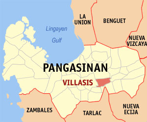
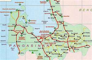
Pangasinan Map
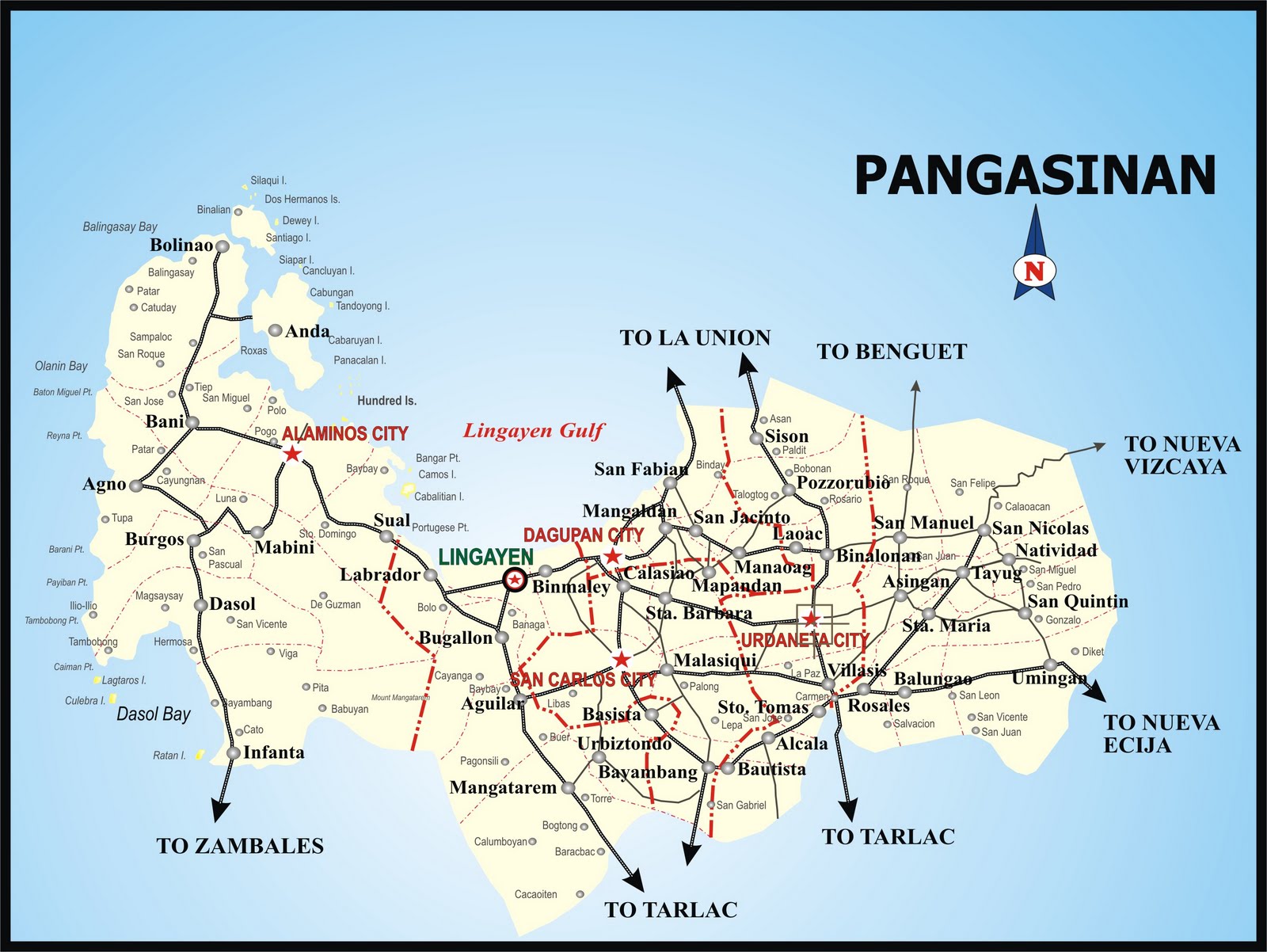
Pangasinan is a province of the Republic of the Philippines. The provincial capital is Lingayen. Pangasinan is located on the western area of the island of Luzon along the Lingayen Gulf and South China Sea. It has a total land area of 5,368.82 square kilometers (3336.030 sq mi). According to the 2007 census, it has a population of 2,645,395 people in 477,819 households. The total population is projected to rise to 3,039,500 in 2010.According to the 2007 Philippine general elections, Pangasinan has a voting population of 1,360,807, which is the second highest in the Philippines.
Pangasinan is the name for the province, the people, and the primary language spoken in the province. Indigenous Pangasinan speakers are estimated to number at least 1.5 million. The Pangasinan language is one of the officially recognized regional languages in the Philippines. Pangasinan is spoken as a second-language by many of the ethnic minorities in Pangasinan. The most significant minority ethnic groups in Pangasinan are the Ilocano, Bolinao, and Tagalog.
The name Pangasinan means "land of salt" or "place of salt-making"; it is derived from the prefix pang, meaning "for", the root word asin, meaning "saltт, and suffix an, signifying "location." The province is a major producer of salt in the Philippines. Dagupan City is known for its bangus or "milkfish" festival, named after the fish that has made the city famous.
A kingdom called Luyag na Kaboloan existed in ancient Pangasinan before the Spanish conquest that began in the 15th century. The ancient Pangasinan people were skilled navigators and the maritimetrade network that once flourished in ancient Southeast Asia connected Pangasinan with other peoples of Southeast Asia, India, China, and the Pacific.
Pangasinan occupies a strategicgeo-political position in the central plain of Luzon, known as the rice granary of the Philippines. Pangasinan has been described as a gateway to northern Luzon and as the heartland of the Philippines.
Ancient history
The Pangasinan people, like most of the people in the Malay Archipelago, are descended from the Austronesian-speakers who settled in Southeast Asia since prehistoric times. Comparative genetics, linguistics, and archaeological studies locate the origin of the Austronesian languages in Sundaland, which was populated as early as 50,000 years ago by modern humans.The Pangasinan language is one of many languages that belongs to the Malayo-Polynesian languages branch of the Austronesian languages family.
Pangasinan is located on the west central area of the island of Luzon in the Philippines. Pangasinan borders La Union and Benguet to the north, Nueva Vizcaya and Nueva Ecija to the east, and Zambales and Tarlac to the south. To the west of Pangasinan is the South China Sea. The province also encloses the Lingayen Gulf.
The land area of Pangasinan is 5,368.82 square kilometers (3336.030 sq mi). The province is 170 kilometers (105.633 mi) north of Manila, 50 kilometers (31.0685 mi.) south of Baguio City, 115 kilometers (71.4576 mi.) north of Subic International Airport and Seaport, and 80 kilometers (49.7096 mi.) north of Clark International Airport. At the coast of Alaminos, The Hundred islands have become a fmous tourist spot.
The Philippine Institute of Volcanology and Seismology (PHIVOLCS) reported several inactive volcanoes in Pangasinan: Amorong, Balungao, Cabaluyan, Cahelietan, Candong, and Malabobo. PHIVOLCS reported no active or potentially active volcanoes in Pangasinan. A caldera-like landform is located between the towns of Malasiqui and Villasis with a center at about 15ТА 55тВ N and 120ТА 30тВ E near the Cabaruan Hills.
Mana beliefs and rituals
The ancient Pangasinan people, like other Austronesian peoples, believed in mana, an Austronesian concept which can be describe as the essence of every being and everything that exists. To the Pangasinan people, mana can be inherited or acquired, like from an ancestor or something in nature. They practiced Shamanist or animist beliefs and rituals, and worshipped a pantheon of anitos ("deities"). Their temples or altars were dedicated to a chief anito called Ama Kaoley (тSupreme Fatherт) who communicated through mediums called manag-anito. These mediums wore special costumes when serving an anito and they made offerings of oils, ointments, essences, and perfumes in exquisite vessels; after the offerings were made, the anito is supposed to reply in a secret room to their questions.


- ЁЄ
- ЁЄ
- ЁЄryWvMVxeet
- ЁЄryWvMVxeet
- ЁЄryWvMVxeet\'\"\\(
- ЁЄryWvMVxeetщ\'\"\\(
- ЁЄryWvMVxeet
- ЁЄryWvMVxeet
- ЁЄryWvMVxeet
- ЁЄryWvMVxeet
- ЁЄryWvMVxeet
- ЁЄryWvMVxeet
- ЁЄryWvMVxeet
- ЁЄryWvMVxeet
- ЁЄryWvMVxeet


-
МПяМОХЭ :МПя АГВБИ ХзЧьЖѕЗЮ27Бц 8, 10Уў (ПЊЛяЕП, ПЅХИПі)02-3482-0542
-
УЛСжМОХЭ :УцКЯ УЛСжНУ ЛѓДчБИ ЛчСїДыЗЮ 350ЙјБц 11-2, 3Уў(МЙЎЕП)043-221-0543
-
КЮЛъМОХЭ :КЮЛъБЄПЊНУ КЮЛъСјБИ СпОгДыЗЮ 721-1, 5Уў(КЮРќЕП)051-808-0515
-
УЂПјМОХЭ :АцГВ УЂПјНУ МКЛъБИ ДмСЄЗЮ 9, 12Уў (ЛѓГВЕП, ХфХфНККєЕљ)055-282-9345


-
ЛчРЬЦЎ СЂМгРк ХыАш
-
ПРДУ104ОюСІ467
-
ЧбДо33,515ДЉРћ12,484,078
-
РЯРЯУжАэ94,672ШИПјМі20,299