


![]()


ЧЪРкДКНК

- ЁЄ ЧЪИЎЧЩ HOT
- ЁЄ ЧбБЙ HOT
- ЁЄ ЧСЗЮИ№МЧ HOT
- ЁЄ ШИЛчМвАГ
 13ГтПЌМг МвКёРкИИСЗ 1РЇ
ЧЪИЎЧЩПЌМіСЄКИ
ЧЪИЎЧЩЧаПјСЄКИ
ЧЪИЎЧЩПЌМіКёПы
ЧЪИЎЧЩУтБЙСиКё
ЧЪИЎЧЩСЄКИ
ЧиПмПЌАшПЌМі
СжДЯОюЧЪИЎЧЩ ПЌМі
ЧЪРкДТУрСІДй
ЧЪИЎЧЩ ЧіСі ЛчЙЋНЧ
ЧЪИЎЧЩПЌМіЧСИЎЙЬОі МКёНК
ЧЪИЎЧЩ ОюЧаПЌМіРЬКЅЦЎ
ЧЪИЎЧЩАЁСЗПЌМі
ЧЪИЎЧЩСЖБтРЏЧа
ЧЪРкДхФФЧиПмЛчЙЋНЧ
 ЧЪРкДхФФ ОпАЃЛѓДу ПРЧТ
 ГЛАд ИТДТ ОюЧаПј УЃБт
 ИЎОѓ ЧаБГ ЙцЙЎБт
 СжИЛПЁ ГЛАЁ ОЕ КёПыРК?
 УжАэАЁМККё РЬКЅЦЎ СёБтБт
 ЧіСіПЁМЕЕ ЧЪРкДхФФ!
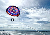 ЧіСіПЁМ АЁДЩЧб


 ЧЪРк ЦЏБо Ч§ХУ! ФСНУОюСі МКёНК


-
МјРЇСІИёСЖШИМі
-
 И№ОЫ КИОЫ Йъ ЗЛЦЎЧЯБт~ ИЎСЖЦЎ ПЙОрБюСі
 89,616
 -
 [ЧЪИЎЧЩ ММКЮ] ФЋИ№ХзНК ПЉЧр 100Йш СёБтБт 49,805
 -
 ИЖДвЖѓ НУГЛ - ИЎРп АјПјСЄКИ. (ЛчСј 16Рх ЦїЧд) 30,850
 -
 ММКЮРЧ СіПЊСЄКИ15,563
 -
 ИЖДвЖѓ БйБГ - ЕћАЁРЬЕћРЬ ПЉЧр СЄКИ14,406
 -
 [ЧЪИЎЧЩ ММКЮ/ИЗХК] ШЃХк МїЙк ПфБн Йз СЄКИ13,360
 -
 КИЖѓФЋРЬРЧ И№Еч И№НРРЛ КММі РжДТ ЛчСјУИ.13,171
 -
 ИЖДвЖѓ БйБГ - ЦХЛѓЧб ЦјЦї ПЉЧрСЄКИ12,872
 -
 [ММКЮ-ЙшМБТјРх] МБЙкШИЛч РќШЙјШЃПЁПф~12,498
 -
 ИЖДвЖѓ СіПЊ(ПЁИЃЙЬХИ -ИЛЖѓХз)РЧ СіЕЕ/ЧбБЙ РННФСЁ/МюЧЮИє12,150


- РЬИЇ : tutors
- РлМКРЯ : 2012-11-05
- СЖШИМі : 20640
- УпУЕМі : 0
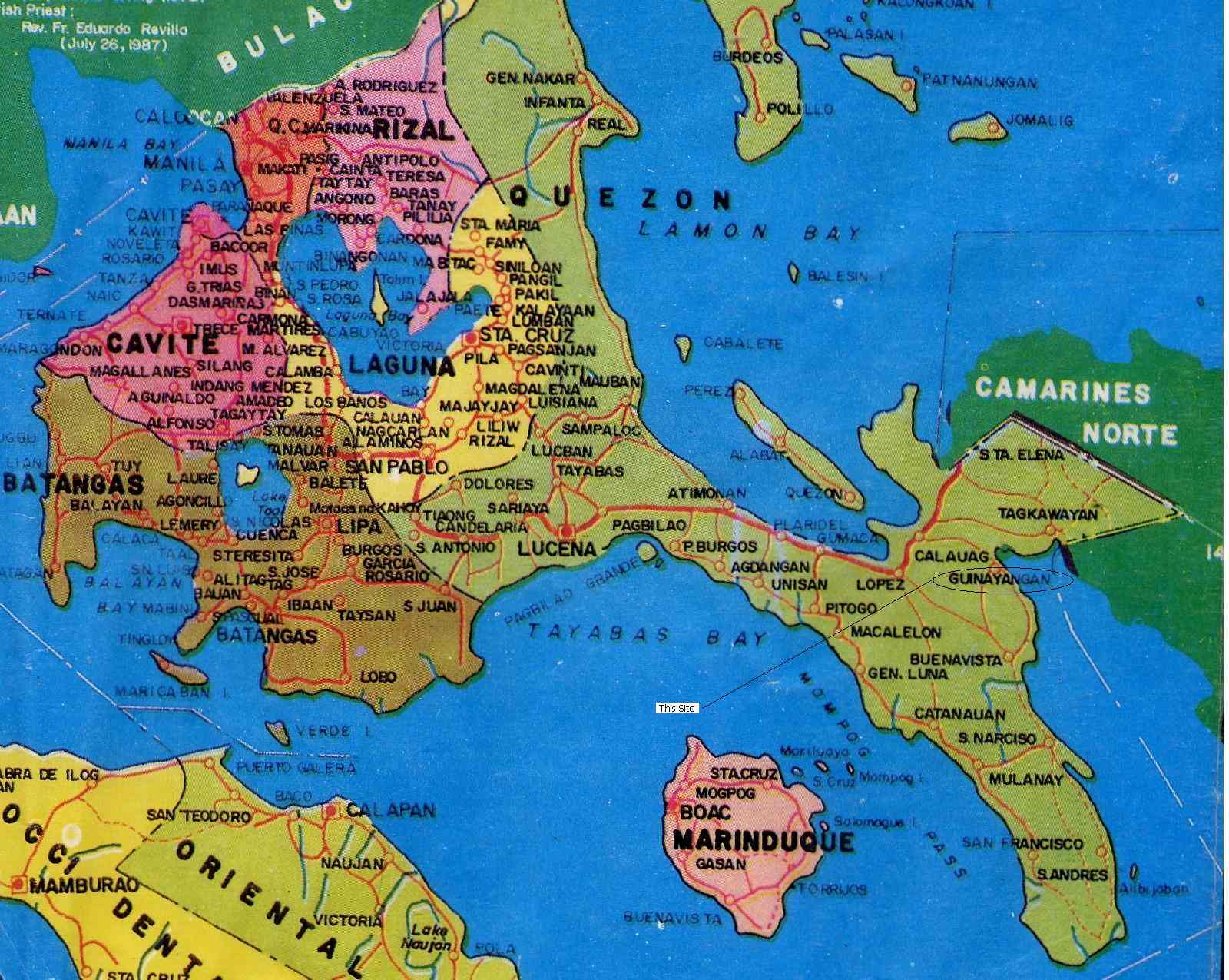
Quezon Province Map
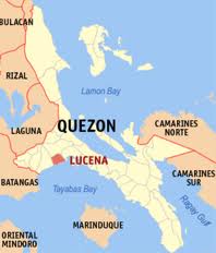
Quezon (Tagalog pronunciation: [keˈzon]) is a province of the Philippines in the CALABARZONregion of Luzon. The province was named after Manuel L. Quezon, the second President of the Philippines, and its capital is Lucena City.
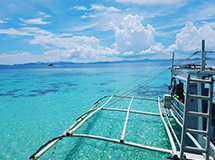
Quezon is southeast of Metro Manila and is bordered by the provinces of Aurora to the north, Bulacan, Rizal, Laguna and Batangas to the west and the Camarines provinces to the east. Part of Quezon lies on an isthmus connecting the Bicol Peninsula to the main part of Luzon island. The province also includes the Polillo Islands in the Philippine Sea.
A major tourism draw to the province is Mt. Banahaw. The mountain is surrounded by spiritual mysticism with many cults and religious organizations staying on the mountain. Numerous pilgrims visit the mountain especially during Holy Week.
History
Originally, what now forms Quezon was divided among the provinces of Batangas, Laguna, and Nueva Ecija. The area was first explored by Juan de Salcedo in 1571-1572, during his expedition from Laguna to Camarines provinces.
In 1591, the province was created and called Kaliraya or Kalilayan, after the capital town which later became Unisan. In about the middle of the 18th century, the capital was transferred to the town of Tayabas, from which the province got its new name.
Depredation and plunder by the Moros were rampant during the Spanish regime, because they opposed the colonizers, especially in their efforts to spread Christianity. The destruction of Kalilayan in 1604 by a big fleet of moro pirates caused the inhabitants to transfer to Palsabangon (Pagbilao).
However, even the colonized people grew discontented with the Spaniards over the centuries. The most important event in the history of the province was the Confradia Revolt in 1841, which was led by the famous Lucbano, Apolinario dela Cruz, popularly known as Hermano Pule. The province, under Gen. Miguel Malvar, was also among the earliest to join the Philippine Revolution. The Revolutionary Government took control over the province on August 15, 1898.
The Americans then came and annexed the Philippines. A civil government was established in the province on March 2, 1901, with Lucena as its capital.
Japanese occupation of the province during World War II began on December 23, 1941, when the Japanese Imperial Army landed in Atimonan. The occupation witnessed the brutal murders of prominent sons of Tayabas. April 4, 1945 was the day the province was liberated as the combined Filipino and American army forces reached Lucena.
After the war, on September 7, 1946, Republic Act No. 14 changed the name Tayabas to Quezon, in honor of Manuel L. Quezon, the Commonwealth president who hailed from Baler, which was one of the province's towns.
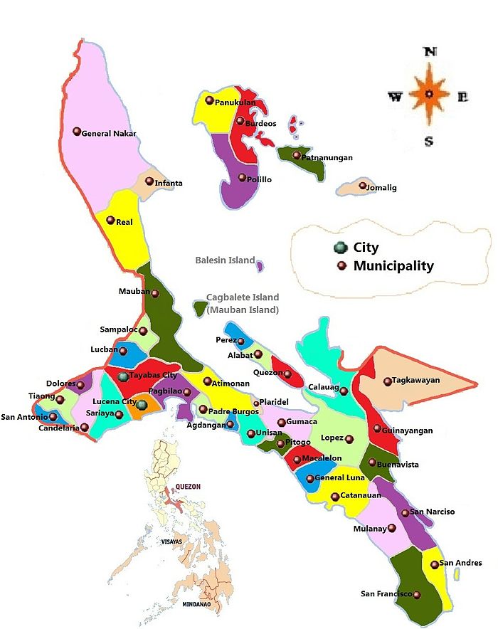
Quezon's division
In 1951, the northern part of Quezon was made into the sub-province of Aurora (which included Baler). Aurora was the name of the president's wife, Aurora Quezon. In 1979, Aurora was separated from Quezon as an independent province.
In 1992, Republic Act No. 9495, which proposed to further divide Quezon into Quezon del Norte and Quezon del Sur lapsed into law without the President's signature on September 7, 2007. Quezon del Norte was to be composed of the first and second congressional districts of the province, with Lucena City as its capital. Quezon del Sur, with its capital at Gumaca, would have been composed of the third and fourth congressional districts. The COMELEC held the plebiscite on December 13, 2008 and majority of the votes cast rejected the division.
Geography
Quezon, east of Metro Manila, is the 8th largest province in the Philippines having an area of 892,601 hectares or 8,926.01 kmТВ. The northern part of the province is sandwiched between the Sierra Madre mountain range and the Philippine Sea. The southern part consists of the Tayabas Isthmus, which separates the Bicol Peninsula from the main part of Luzon Island, and the Bondoc Peninsula which lies between Tayabas Bay and Ragay Gulf.
The major islands of Quezon are Alabat Island and Polillo Islands. Mt. Banahaw, an extinct volcano, is the highest peak at 2,188 m. It supplies geothermal power to the Makban Geothermal Power Plant.


- ЁЄ
- ЁЄ
- ЁЄ
- ЁЄ
- ЁЄryWvMVxeet
- ЁЄryWvMVxeet
- ЁЄryWvMVxeet\'\"\\(
- ЁЄryWvMVxeetщ\'\"\\(
- ЁЄryWvMVxeet
- ЁЄryWvMVxeet
- ЁЄryWvMVxeet
- ЁЄryWvMVxeet
- ЁЄryWvMVxeet
- ЁЄryWvMVxeet
- ЁЄryWvMVxeet


-
МПяМОХЭ :МПя АГВБИ ХзЧьЖѕЗЮ27Бц 8, 10Уў (ПЊЛяЕП, ПЅХИПі)02-3482-0542
-
УЛСжМОХЭ :УцКЯ УЛСжНУ ЛѓДчБИ ЛчСїДыЗЮ 350ЙјБц 11-2, 3Уў(МЙЎЕП)043-221-0543
-
КЮЛъМОХЭ :КЮЛъБЄПЊНУ КЮЛъСјБИ СпОгДыЗЮ 721-1, 5Уў(КЮРќЕП)051-808-0515
-
УЂПјМОХЭ :АцГВ УЂПјНУ МКЛъБИ ДмСЄЗЮ 9, 12Уў (ЛѓГВЕП, ХфХфНККєЕљ)055-282-9345


-
ЛчРЬЦЎ СЂМгРк ХыАш
-
ПРДУ373ОюСІ361
-
ЧбДо33,515ДЉРћ12,517,549
-
РЯРЯУжАэ94,672ШИПјМі20,299