


![]()


 ЧЪРкДхФФ ОпАЃЛѓДу ПРЧТ
 13ГтПЌМг МвКёРкИИСЗ 1РЇ
 ГЛАд ИТДТ ОюЧаПј УЃБт
 ИЎОѓ ЧаБГ ЙцЙЎБт
 СжИЛПЁ ГЛАЁ ОЕ КёПыРК?
 УжАэАЁМККё РЬКЅЦЎ СёБтБт
 ЧіСіПЁМЕЕ ЧЪРкДхФФ!
 ЧіСіПЁМ АЁДЩЧб


 ЧЪРк ЦЏБо Ч§ХУ! ФСНУОюСі МКёНК


-
МјРЇСІИёСЖШИМі
-
 И№ОЫ КИОЫ Йъ ЗЛЦЎЧЯБт~ ИЎСЖЦЎ ПЙОрБюСі
 89,698
 -
 [ЧЪИЎЧЩ ММКЮ] ФЋИ№ХзНК ПЉЧр 100Йш СёБтБт 50,235
 -
 ИЖДвЖѓ НУГЛ - ИЎРп АјПјСЄКИ. (ЛчСј 16Рх ЦїЧд) 30,888
 -
 ММКЮРЧ СіПЊСЄКИ15,580
 -
 ИЖДвЖѓ БйБГ - ЕћАЁРЬЕћРЬ ПЉЧр СЄКИ14,468
 -
 [ЧЪИЎЧЩ ММКЮ/ИЗХК] ШЃХк МїЙк ПфБн Йз СЄКИ13,394
 -
 КИЖѓФЋРЬРЧ И№Еч И№НРРЛ КММі РжДТ ЛчСјУИ.13,199
 -
 ИЖДвЖѓ БйБГ - ЦХЛѓЧб ЦјЦї ПЉЧрСЄКИ12,907
 -
 [ММКЮ-ЙшМБТјРх] МБЙкШИЛч РќШЙјШЃПЁПф~12,526
 -
 ИЖДвЖѓ СіПЊ(ПЁИЃЙЬХИ -ИЛЖѓХз)РЧ СіЕЕ/ЧбБЙ РННФСЁ/МюЧЮИє12,186


- РЬИЇ : tutors
- РлМКРЯ : 2013-02-04
- СЖШИМі : 26410
- УпУЕМі : 0
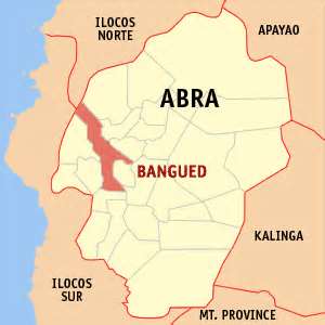
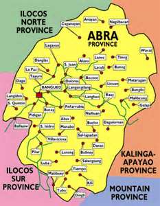
Abra Province, Philippines
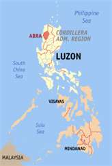
Abra (Ilokano: Probinsya ti Abra), (Tagalog: Lalawigan ng Abra), is a landlocked province of the Philippines in the Cordillera Administrative Region in Luzon. Its capital is Bangued, and it borders Ilocos Norte and Apayao on the north, Ilocos Sur and Mountain Province on the south, Ilocos Nortand Ilocos Sur on the west, and Kalinga, and Apayao on the east.
Demographics
Abra's inhabitants are mostly descendants of Ilocano settlers and members of the Tingguian tribe. As of 2011, the population of the province is 240,141.
The predominant languages are Ilocano and Itneg.Based on the 2000 census survey, the majority of the province population is Ilocano 71.9%. Other ethnic groups living in the province are the Tinguian 18.7%, Ibanag 4.5%, Isneg 3.2% and Tagalog 0.4%.
History
The first inhabitants of Abra were the ancestors of the Bontocs and the Ifugaos. These inhabitants eventually left to settle in the old Mountain Province. Other early inhabitants were the Tingguians, or Itnegs, as they are also known. In 1598 a Spanish garrison was established in Bangued to protect the Ilocanos who converted to Christianity from Tingguian raids. During the British Occupation of the Philippines, Gabriela Silang and her army fled to Abra from Ilocos and continued the revolt begun by her slain husband, Diego Silang. She was captured and hung by the Spanish in 1763.
In 1818 the Ilocos region, including Abra, was divided into Ilocos Norte and Ilocos Sur. In 1846 Abra was created as a political-military province with Lepanto as a sub-province. It remained so until the arrival of the Americans in 1899.
In 1908 the Philippine Commission once again in annexed Abra to Ilocos Sur in an attempt to resolve Abra's financial difficulties. But on March 9, 1917, the Philippine Assembly re-established Abra as a province.
In 1942, the Japanese forces occupied the Philippines and entered Abra.
The built of the local military general headquarters of the Philippine Commonwealth Army was active on 1942 to 1946, the Philippine Constabulary was found active from 1944 to 1946 and the United States Armed Forces in the Philippines - Northern Luzon or USAFIP-NL was active again from 1942 to 1946 and military stationed in the province of Abra during the Japanese Occupation and the Allied Liberation.
In 1945, the liberation in Abra in Northern Luzon by the Philippine Commonwealth forces and the local Cordilleran guerrillas against the Japanese during the Battle of Abra at the end the Second World War.
The revolutionary Marxist priest, Conrado Balweg, who fought for the rights of the Cordillera tribes, began his crusade in Abra. After successfully negotiating a peace accord with Balweg's group in 1987, the Philippine government created the Cordillera Administrative Region, which includes Abra.
Physical
Abra is hemmed in by the towering mountain ranges of the Ilocos in the west and the Cordillera Central in the east. It has an extremely rugged terrain, with mountains and hills rising along its perimeter and interior. The plains are drained by the Abra River, which flows northward from Mt. Data in the Mountain Province.
Economy
As of 1990, there were 743 cottage industries in Abra, of which 208 are registered with the Department of Trade and Industry. 59% are engaged in bamboo and rattan craft making, both leading industries in the area.
In 1992, the natural dye industry, together with loomweaving and embroidery, was revived by former Governor Ma. Zita Claustro-Valera, the first woman governor of Abra.
Abra's economy is agriculture-based. Its major crops are rice, corn, and root crops; and commercial produce are coffee, tobacco, and coconut. Extensive grassland and pasture areas are used for livestock production.


- ЁЄ
- ЁЄ
- ЁЄ
- ЁЄ
- ЁЄ
- ЁЄryWvMVxeet
- ЁЄryWvMVxeet
- ЁЄryWvMVxeet\'\"\\(
- ЁЄryWvMVxeetщ\'\"\\(
- ЁЄryWvMVxeet
- ЁЄryWvMVxeet
- ЁЄryWvMVxeet
- ЁЄryWvMVxeet
- ЁЄryWvMVxeet
- ЁЄryWvMVxeet


-
МПяМОХЭ :МПя АГВБИ ХзЧьЖѕЗЮ27Бц 8, 10Уў (ПЊЛяЕП, ПЅХИПі)02-3482-0542
-
УЛСжМОХЭ :УцУЛКЯЕЕ УЛСжНУ ШяДіБИ МЧіЕПЗЮ 4, 3Уў(АЁАцЕП)043-221-0543
-
КЮЛъМОХЭ :КЮЛъБЄПЊНУ КЮЛъСјБИ СпОгДыЗЮ 721-1, 5Уў(КЮРќЕП)051-808-0515
-
УЂПјМОХЭ :АцГВ УЂПјНУ МКЛъБИ ДмСЄЗЮ 9, 12Уў (ЛѓГВЕП, ХфХфНККєЕљ)055-282-9345


-
ЛчРЬЦЎ СЂМгРк ХыАш
-
ПРДУ104ОюСІ404
-
ЧбДо33,515ДЉРћ12,530,584
-
РЯРЯУжАэ94,672ШИПјМі20,299