


 ЧЪРкДхФФ ОпАЃЛѓДу ПРЧТ
 11ГтПЌМг МвКёРкИИСЗ 1РЇ
 ГЛАд ИТДТ ОюЧаПј УЃБт
 ИЎОѓ ЧаБГ ЙцЙЎБт
 СжИЛПЁ ГЛАЁ ОЕ КёПыРК?
 УжАэАЁМККё РЬКЅЦЎ СёБтБт
 ЧіСіПЁМЕЕ ЧЪРкДхФФ!
 ЧіСіПЁМ АЁДЩЧб


 ЧЪРк ЦЏБо Ч§ХУ! ФСНУОюСі МКёНК


 АЁСЗПЌМіЗЮ ДйЧдАд ОзЦМКёЦМ

-
МјРЇСІИёСЖШИМі
-
 И№ОЫ КИОЫ Йъ ЗЛЦЎЧЯБт~ ИЎСЖЦЎ ПЙОрБюСі
 88,205
 -
 [ЧЪИЎЧЩ ММКЮ] ФЋИ№ХзНК ПЉЧр 100Йш СёБтБт 38,683
 -
 ИЖДвЖѓ НУГЛ - ИЎРп АјПјСЄКИ. (ЛчСј 16Рх ЦїЧд) 30,144
 -
 ММКЮРЧ СіПЊСЄКИ15,141
 -
 ИЖДвЖѓ БйБГ - ЕћАЁРЬЕћРЬ ПЉЧр СЄКИ13,669
 -
 [ЧЪИЎЧЩ ММКЮ/ИЗХК] ШЃХк МїЙк ПфБн Йз СЄКИ12,676
 -
 КИЖѓФЋРЬРЧ И№Еч И№НРРЛ КММі РжДТ ЛчСјУИ.12,556
 -
 ИЖДвЖѓ БйБГ - ЦХЛѓЧб ЦјЦї ПЉЧрСЄКИ12,109
 -
 [ММКЮ-ЙшМБТјРх] МБЙкШИЛч РќШЙјШЃПЁПф~11,678
 -
 ИЖДвЖѓ СіПЊ(ПЁИЃЙЬХИ -ИЛЖѓХз)РЧ СіЕЕ/ЧбБЙ РННФСЁ/МюЧЮИє11,570


- РЬИЇ : tutors
- РлМКРЯ : 2012-08-15
- СЖШИМі : 2146
- УпУЕМі : 0

Dapitan
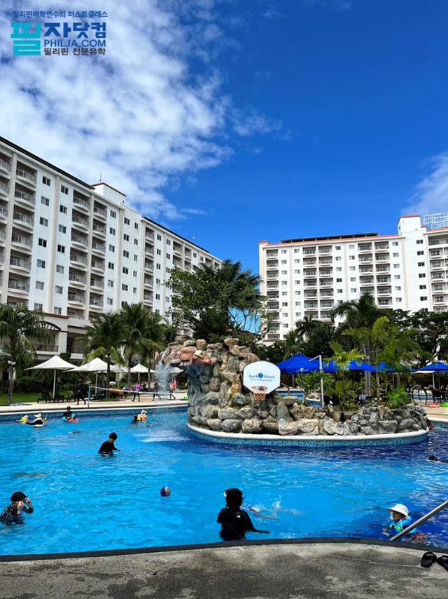
The City of Dapitan (Subanen: Gembagel G'benwa Dapitan/Bagbenwa Dapitan, Cebuano: Dakbayan sa Dapitan, Spanish/Chavacano: Ciudad de Dapitan) is a 6th class city in the province of Zamboanga del Norte, Philippines. According to the 2010 census, it has a population of 77,441 inhabitants. It is historically significant as being the place where the national hero, Jose Rizal was exiled by the Spaniards and is known as the "Shrine City in the Philippines." The city also boasts of Fantasyland, the first amusement park in the Visayas-Mindanao region. Dapitan is notoriously known as the principal base of the infamous Jalosjos political clan.
History
The beginnings of the settlement now known as the city of Dapitan predates the arrival of the Spanish conquistadores on the island of Mindanao. The Subanens, a nomadic tribe of Indo-Malayan stock, were the earliest known settlers who lived along river banks or "suba", from which word they received their present tribal identity as Subanen. However, it is believed that the timid Subanens were forced to move further into the hinterlands of the Zamboanga peninsula out of fear that pirates may seek shelter during foul weather in the natural harbors of Dapitanтs irregular coastlines. They are now mainly found in the mountainous areas of Zamboanga del Sur and Misamis Occidental.
Early cartographers of the Philippines showed Dapitanтs location in their maps of Mindanao using a variety of names by which they had known the settlement, such as тDapitoт in Kaeriusт map of 1598, тDapiteт in Dudleyтs map of 1646, тDapytoт in Sansonтs map of 1652, and тDapitanт in Mollтs map of the East Indies of 1729 and in Murillo Velardeтs map of 1734.
There are two versions of how Dapitan got its name. The first, from an account attributed to Fr. Urdaneta, infers that the name evolved from the original reference to it as "Daquepitan", which later became "Dacpitan" and finally "Dapitan" to make it easier to pronounce.
The second version, which is more widely accepted according to folklore, says that the name derives from the Cebuano word тDapitт, which means тto inviteт. Local tradition tells of the early settlers from Panglao in Bohol who were invited over by Datu Pagbuaya, the acknowledged founder of Dapitan, to join him in "Dakung Yuta", or literally the big land that is Mindanao. The invitation or pag-dapit that he extended to Boholanos is said to be how Dapitan got its name.
Various historical accounts also indicate that trading voyages and commercial relations existed with the nascent but thriving settlement of Dapitan. This interaction with traders from the different cultures in the region may have had some influence on the cultural evolution of Dapitan itself. The influence of the Spaniards, the Americans, the Japanese, and the different Visayan ethnolinguistic groups that settled here could not also be discounted in their contributions toward the evolution and emergence of a distinctly Dapitanon culture.
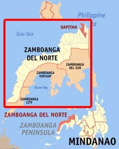
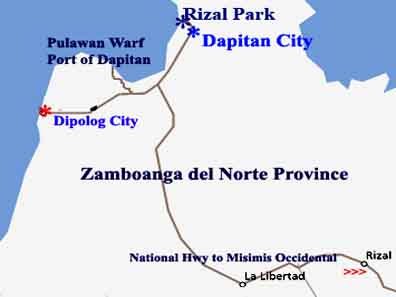
Geographical Location
Dapitan City lies on the Northern tip of Zamboanga del Norte and northwestern coast of the island of Mindanao with approximate geographical coordinates of 8o50т North latitude and 123o30т East longitude. It is about 404 nautical miles (or 650 kilometers) southwest of Metropolitan Manila; 156 nautical miles to Zamboanga City; 111 nautical miles to Cebu City; 44 nautical miles to Dumaguete City; and 14 kilometers to Dipolog City.
It is a double wedge-shaped mass of land bounded on the north by the Sulu Sea and link on the south by the Municipalities of Mutia and La Libertad, on the east by the Municipalities of Sibutad and Rizal, on the west by Dipolog City and the Municipalities of Polanco, Sibutad, La Libertad and Rizal, all of the province of Zamboanga del Norte.
Demography
|
Growth Rate
The earliest recorded census in 1903 showed Dapitan with a population of only 8,086. Its population rose to 28,295 in 1939 and further to 37,984 in 1948. In 1960, however, the cityтs population dropped by 10,467 (-2.65%) following the separation of Sibutad, La Libertad and Rizal from Dapitan to become separate municipalities of the Province of Zamboanga del Norte. From 1970 onwards, Dapitanтs population showed an increasing trend in the average growth rate as indicated on the Table.
According to the 2000 Census of Population of the City it has a total population of 68,178 persons while projections showed that by this year 2008 the total projected population of the city is 77,339 based on the Average Growth Rate of 1.59% per annum.
HISTORICAL GROWTH OF POPULATION AND GROWTH RATE Dapitan City 1903–2000
Source: National Statistics Office (NSO), Dipolog City
Distribution and Location
Urban population density in 2000 averaged 26 persons per hectare while the rural areas have an average population density of only 2 persons per hectare. By the year 2010, it is expected that the urban population density will be 31 persons per hectare while rural population density will remain at 2 persons per hectare.
There were 13,560 households in 2000 with four out of every five households located in the rural areas. The average household size of the whole city was 5.4 persons. | |||||||||


- ЁЄ
- ЁЄ
- ЁЄ
- ЁЄ
- ЁЄ
- ЁЄ
- ЁЄ
- ЁЄ
- ЁЄ
- ЁЄNmjNUuzXqd
- ЁЄNmjNUuzXqd
- ЁЄNmjNUuzXqd
- ЁЄNmjNUuzXqd
- ЁЄNmjNUuzXqd
- ЁЄNmjNUuzXqd


-
МПяМОХЭ :МПя АГВБИ ХзЧьЖѕЗЮ27Бц 8, 10Уў (ПЊЛяЕП, ПЅХИПі)02-3482-0542
-
УЛСжМОХЭ :УцКЯ УЛСжНУ ЛѓДчБИ ЛчСїДыЗЮ 350ЙјБц 11-2, 3Уў(МЙЎЕП)043-221-0543
-
КЮЛъМОХЭ :КЮЛъБЄПЊНУ КЮЛъСјБИ СпОгДыЗЮ 721-1, 5Уў(КЮРќЕП)051-808-0515
-
УЂПјМОХЭ :АцГВ УЂПјНУ МКЛъБИ ДмСЄЗЮ 9, 12Уў (ЛѓГВЕП, ХфХфНККєЕљ)055-282-9345


-
ЛчРЬЦЎ СЂМгРк ХыАш
-
ПРДУ128ОюСІ461
-
ЧбДо33,515ДЉРћ12,189,572
-
РЯРЯУжАэ94,672ШИПјМі20,299