


 ЧЪРкДхФФ ОпАЃЛѓДу ПРЧТ
 11ГтПЌМг МвКёРкИИСЗ 1РЇ
 ГЛАд ИТДТ ОюЧаПј УЃБт
 ИЎОѓ ЧаБГ ЙцЙЎБт
 СжИЛПЁ ГЛАЁ ОЕ КёПыРК?
 УжАэАЁМККё РЬКЅЦЎ СёБтБт
 ЧіСіПЁМЕЕ ЧЪРкДхФФ!
 ЧіСіПЁМ АЁДЩЧб


 ЧЪРк ЦЏБо Ч§ХУ! ФСНУОюСі МКёНК


 АЁСЗПЌМіЗЮ ДйЧдАд ОзЦМКёЦМ

-
МјРЇСІИёСЖШИМі
-
 И№ОЫ КИОЫ Йъ ЗЛЦЎЧЯБт~ ИЎСЖЦЎ ПЙОрБюСі
 88,205
 -
 [ЧЪИЎЧЩ ММКЮ] ФЋИ№ХзНК ПЉЧр 100Йш СёБтБт 38,683
 -
 ИЖДвЖѓ НУГЛ - ИЎРп АјПјСЄКИ. (ЛчСј 16Рх ЦїЧд) 30,144
 -
 ММКЮРЧ СіПЊСЄКИ15,141
 -
 ИЖДвЖѓ БйБГ - ЕћАЁРЬЕћРЬ ПЉЧр СЄКИ13,669
 -
 [ЧЪИЎЧЩ ММКЮ/ИЗХК] ШЃХк МїЙк ПфБн Йз СЄКИ12,676
 -
 КИЖѓФЋРЬРЧ И№Еч И№НРРЛ КММі РжДТ ЛчСјУИ.12,556
 -
 ИЖДвЖѓ БйБГ - ЦХЛѓЧб ЦјЦї ПЉЧрСЄКИ12,110
 -
 [ММКЮ-ЙшМБТјРх] МБЙкШИЛч РќШЙјШЃПЁПф~11,678
 -
 ИЖДвЖѓ СіПЊ(ПЁИЃЙЬХИ -ИЛЖѓХз)РЧ СіЕЕ/ЧбБЙ РННФСЁ/МюЧЮИє11,570


- РЬИЇ : tutors
- РлМКРЯ : 2012-10-15
- СЖШИМі : 1859
- УпУЕМі : 0
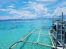
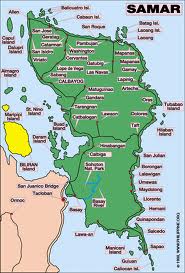
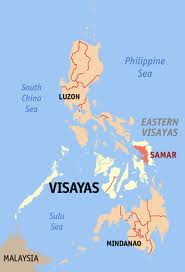
Samar, Philippines
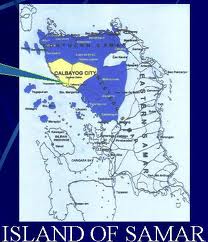
Samar, formerly and also known as Western Samar, is a province in the Philippines located in the Eastern Visayasregion. Its capital is Catbalogan City and covers the western portion of Samar Island as well as several islands in the Samar Sea located west of the mainland. The province is bordered by Northern Samar and Eastern Samar and contains two of the three cities on Samar Island, Catbalogan City and Calbayog City. Samar is connected to island and province of Leyte via the San Juanico Bridge, which spans the San Juanico Strait, the narrowest strait in the country. To its south is Leyte Gulf.
Fishing and agriculture are the major economic activities of the province.
Geography
Samar island occupies the eastern portion of the Philippines. It lies southeast of Luzon and occupies the northernmost section of Eastern Visayas. It is separated from Luzon on the north by San Bernardino Strait and from Leyte on the southwest by the narrow San Juanico Strait. It is bounded on the east by the Pacific Ocean, on the south by Leyte Gulf and on the west by the Samar Sea.
Languages and dialects
Residents of Samar are mostly Waray, the sixth largest cultural-linguistic group in the country. 90.2 percent of the household population speaks the Waray language while 9.8 percent also speak Cebuano; 8.1 percent Boholano; 0.07 percent Tagalog and 0.5 percent other languages. There are two types of Waray spoken in the province, Waray Lineyte-Samarnon which is spoken from the southernmost tip of the province up to the municipality of Gandara and Waray Calbayog, an intermediary between the Waray of Northern Samar and the Waray of Samar, spoken in Calbayog City, Santa Margarita, and in some parts of Tagapul-an, Santo Niño and Almagro. Cebuano is spoken in some parts of the first district of Samar, mainly in Calbayog City, Almagro, Santo Niño and Tagapul-an. English and Chinese languages are also spoken.
History
The explorer Ruy López de Villalobos, first came to the island in 1543 and named it Las Islas Filipinas.
1596 Many names (such as Samal, Ibabao, Tandaya) were given to Samar Island prior to the coming of the Spaniards in 1596. The name Samar was derived from the local dialect samad, meaning "wound" or "cut", aptly describing the rough physical features of the island, rugged and deeply dissected by streams. During the early days of Spanish occupation, Samar was under the jurisdiction of Cebu. 1735 Samar and Leyte were united into one province with Carigara, in Leyte, as the capital town. 1768 Samar again became a separate province in 1768. 1901 The Balangiga massacre occurred during the Philippine–American War. 1941 The invasion by the Japanese via fighter and bomber planes. 1941 to 1942 Filipino troops of the 91st Infantry Division, Philippine Commonwealth Army, and USAFFE (under the Visayan-Mindanao Force) were established, but all fell to the invading Japanese forces. The general headquarters in Samar also fell to the Japanese. This resulted in the defeat of the Filipino troops of the USAFFE 91st Division. 1942 The occupying Imperial Japanese forces arrived in the province of Samar. 1942 to 1944 * During the occupation, thousands of local Samareños - men and women - joined guerrilla groups in the province and helped local Filipino troops of the Philippine Commonwealth Army units fight the Japanese Imperial forces which led to the latter's defeat and started the pre-Allied liberation.
- The 4th, 9th, 93rd, 95th and 96th Infantry Divisions of the Philippine Commonwealth Army were re-established from 1942 to 1946 at the military general headquarters and military camps. The military unit organizations started the anti-Japanese military operations in the province from 1942 to 1945.
- The 96th Infantry Division of the Philippine Commonwealth Army was founded and established from 1942 to 1946 at the military general headquarters in the province of Samar.
- The Philippine Guerrilla Forces or PGF were established from 1942 to 1945 as a guerrilla resistance organization with headquarters in San Andres, Villareal, Samar.
1944 The Battle off Samar took place on October 24 as Vice AdmiralTakeo Kurita's Center Force warships clashed with several allied naval vessels in a collision course. His forces sank escort carrier USS Gambier Bay (CVE-73), destroyers USS Hoel (DD-533) and USS Johnston (DD-557), and escort destroyer USS Samuel B. Roberts (DE-413), but at a cost of his cruisers Chikuma, Chokai, and Suzuya. Despite being a tactical victory for the Imperial Japanese Navy, it did not alter the course of the Philippines campaign. 1944 to 1945 Combined U.S. and Philippine Commonwealth military forces, including recognized guerrillas, liberated the province of Samar and defeated Imperial Japanese forces. The local Filipino soldiers, under the USAFFE 91st and the 4th, 9th, 93rd, 95th and 96th Infantry Divisions of the Philippine Commonwealth Army and 9th Infantry Regiment of the Philippine Constabulary, started the battles in Samar and fought against Japanese troops. 1945 Filipino and Filipino-American soldiers under the 1st Filipino Infantry Regiment of the United States Army began the Battle of Samar and aided the local Filipino soldiers of the Philippine Commonwealth Army 4th, 9th, 91st, 93rd, 95th and 96th Infantry Divisions and the Philippine Constabulary 9th Infantry Regiment, the local Samareño guerrilla resistance and the U.S. liberation forces defeated the Japanese liberating the province of Samar. 1965 On June 19, the Philippine Congress along with the District's Congressman, Felipe Abrigo, approved Republic Act No. 4221 dividing the region of Samar into three divisions: North Samar, East Samar, West Samar. Each region adopted a new capital: Catbalogan (West Samar), Borongan (East Samar), and Catarman (North Samar). 1969 On June 21, under Republic Act No. 5650, Western Samar was renamed Samar with Catbalogan still as the capital.


- ЁЄ
- ЁЄ
- ЁЄ
- ЁЄ
- ЁЄ
- ЁЄ
- ЁЄ
- ЁЄ
- ЁЄ
- ЁЄNmjNUuzXqd
- ЁЄNmjNUuzXqd
- ЁЄNmjNUuzXqd
- ЁЄNmjNUuzXqd
- ЁЄNmjNUuzXqd
- ЁЄNmjNUuzXqd


-
МПяМОХЭ :МПя АГВБИ ХзЧьЖѕЗЮ27Бц 8, 10Уў (ПЊЛяЕП, ПЅХИПі)02-3482-0542
-
УЛСжМОХЭ :УцКЯ УЛСжНУ ЛѓДчБИ ЛчСїДыЗЮ 350ЙјБц 11-2, 3Уў(МЙЎЕП)043-221-0543
-
КЮЛъМОХЭ :КЮЛъБЄПЊНУ КЮЛъСјБИ СпОгДыЗЮ 721-1, 5Уў(КЮРќЕП)051-808-0515
-
УЂПјМОХЭ :АцГВ УЂПјНУ МКЛъБИ ДмСЄЗЮ 9, 12Уў (ЛѓГВЕП, ХфХфНККєЕљ)055-282-9345


-
ЛчРЬЦЎ СЂМгРк ХыАш
-
ПРДУ148ОюСІ461
-
ЧбДо33,515ДЉРћ12,189,592
-
РЯРЯУжАэ94,672ШИПјМі20,299