


![]()


ЧЪРкДКНК

- ЁЄ ЧЪИЎЧЩ HOT
- ЁЄ ЧбБЙ HOT
- ЁЄ ЧСЗЮИ№МЧ HOT
- ЁЄ ШИЛчМвАГ
 13ГтПЌМг МвКёРкИИСЗ 1РЇ
ЧЪИЎЧЩПЌМіСЄКИ
ЧЪИЎЧЩЧаПјСЄКИ
ЧЪИЎЧЩПЌМіКёПы
ЧЪИЎЧЩУтБЙСиКё
ЧЪИЎЧЩСЄКИ
ЧиПмПЌАшПЌМі
СжДЯОюЧЪИЎЧЩ ПЌМі
ЧЪРкДТУрСІДй
ЧЪИЎЧЩ ЧіСі ЛчЙЋНЧ
ЧЪИЎЧЩПЌМіЧСИЎЙЬОі МКёНК
ЧЪИЎЧЩ ОюЧаПЌМіРЬКЅЦЎ
ЧЪИЎЧЩАЁСЗПЌМі
ЧЪИЎЧЩСЖБтРЏЧа
ЧЪРкДхФФЧиПмЛчЙЋНЧ
 ЧЪРкДхФФ ОпАЃЛѓДу ПРЧТ
 ГЛАд ИТДТ ОюЧаПј УЃБт
 ИЎОѓ ЧаБГ ЙцЙЎБт
 СжИЛПЁ ГЛАЁ ОЕ КёПыРК?
 УжАэАЁМККё РЬКЅЦЎ СёБтБт
 ЧіСіПЁМЕЕ ЧЪРкДхФФ!
 ЧіСіПЁМ АЁДЩЧб


 ЧЪРк ЦЏБо Ч§ХУ! ФСНУОюСі МКёНК


-
МјРЇСІИёСЖШИМі
-
 И№ОЫ КИОЫ Йъ ЗЛЦЎЧЯБт~ ИЎСЖЦЎ ПЙОрБюСі
 89,624
 -
 [ЧЪИЎЧЩ ММКЮ] ФЋИ№ХзНК ПЉЧр 100Йш СёБтБт 49,838
 -
 ИЖДвЖѓ НУГЛ - ИЎРп АјПјСЄКИ. (ЛчСј 16Рх ЦїЧд) 30,854
 -
 ММКЮРЧ СіПЊСЄКИ15,564
 -
 ИЖДвЖѓ БйБГ - ЕћАЁРЬЕћРЬ ПЉЧр СЄКИ14,412
 -
 [ЧЪИЎЧЩ ММКЮ/ИЗХК] ШЃХк МїЙк ПфБн Йз СЄКИ13,365
 -
 КИЖѓФЋРЬРЧ И№Еч И№НРРЛ КММі РжДТ ЛчСјУИ.13,178
 -
 ИЖДвЖѓ БйБГ - ЦХЛѓЧб ЦјЦї ПЉЧрСЄКИ12,878
 -
 [ММКЮ-ЙшМБТјРх] МБЙкШИЛч РќШЙјШЃПЁПф~12,503
 -
 ИЖДвЖѓ СіПЊ(ПЁИЃЙЬХИ -ИЛЖѓХз)РЧ СіЕЕ/ЧбБЙ РННФСЁ/МюЧЮИє12,154


- РЬИЇ : jilo
- РлМКРЯ : 2011-09-28
- СЖШИМі : 3087
- УпУЕМі : 1
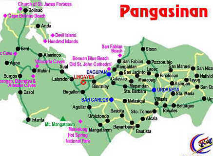
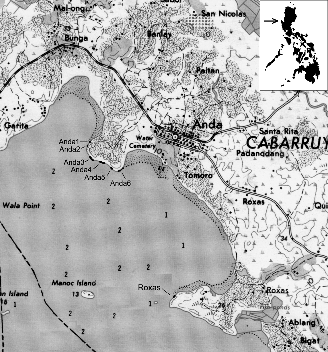
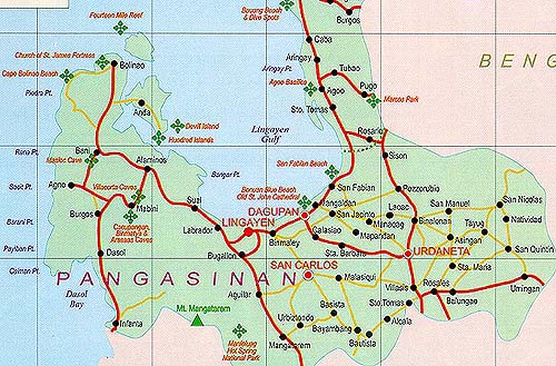
Pangasinan is a province of the Republic of the Philippines. The provincial capital is Lingayen. Pangasinan is
located on the west central and peripheral area of the island of Luzon along the Lingayen Gulf, with the total land area being 5,368.82 square kilometers (3336.030 sq mi). According to the latest census, it has a population of 2,645,395 people in 477,819 households. The total population is projected to rise to 3,039,500 in 2010.[1] According to
the 2007 Philippine general elections, Pangasinan has a voting population of 1,360,807, which is the second
highest in the Philippines.
Pangasinan is the name for the province, the people, and the primary language spoken in the province. Indigenous Pangasinan speakers are estimated to number at least 1.5 million. Pangasinan is spoken as a second-language by many of the ethnic minorities in Pangasinan. The most significant minority ethnic groups in Pangasinan
are the Ilocano, Bolinao, and Tagalog.
The name Pangasinan means "land of salt" or "place of salt-making"; it is derived from the words Pang, meaning for and asin, meaning "saltт, or For Salt in the Pangasinan language and other related languages. The province
is a major producer of salt in the Philippines. Dagupan City is known for it's Bangus festival named after the fish
they widely produce and made the city famous.
An ancient kingdom called Luyag na Kaboloan existed in Pangasinan before the Spanish conquest that began in the 15th century. The maritime trade network that once flourished in ancient Southeast Asia connected Pangasinan with other peoples of Southeast Asia, India, China, and the Pacific.
Pangasinan occupies a strategic geo-political position in the central plain of Luzon, known as the rice granary of the Philippines. Pangasinan has been described as a gateway to northern Luzon and as the heartland of the
Philippines


- ЁЄ
- ЁЄ
- ЁЄ
- ЁЄ
- ЁЄryWvMVxeet
- ЁЄryWvMVxeet
- ЁЄryWvMVxeet\'\"\\(
- ЁЄryWvMVxeetщ\'\"\\(
- ЁЄryWvMVxeet
- ЁЄryWvMVxeet
- ЁЄryWvMVxeet
- ЁЄryWvMVxeet
- ЁЄryWvMVxeet
- ЁЄryWvMVxeet
- ЁЄryWvMVxeet


-
МПяМОХЭ :МПя АГВБИ ХзЧьЖѕЗЮ27Бц 8, 10Уў (ПЊЛяЕП, ПЅХИПі)02-3482-0542
-
УЛСжМОХЭ :УцУЛКЯЕЕ УЛСжНУ ШяДіБИ МЧіЕПЗЮ 4, 3Уў043-221-0543
-
КЮЛъМОХЭ :КЮЛъБЄПЊНУ КЮЛъСјБИ СпОгДыЗЮ 721-1, 5Уў(КЮРќЕП)051-808-0515
-
УЂПјМОХЭ :АцГВ УЂПјНУ МКЛъБИ ДмСЄЗЮ 9, 12Уў (ЛѓГВЕП, ХфХфНККєЕљ)055-282-9345


-
ЛчРЬЦЎ СЂМгРк ХыАш
-
ПРДУ5ОюСІ520
-
ЧбДо33,515ДЉРћ12,518,547
-
РЯРЯУжАэ94,672ШИПјМі20,299