


 ЧЪРкДхФФ ОпАЃЛѓДу ПРЧТ
 11ГтПЌМг МвКёРкИИСЗ 1РЇ
 ГЛАд ИТДТ ОюЧаПј УЃБт
 ИЎОѓ ЧаБГ ЙцЙЎБт
 СжИЛПЁ ГЛАЁ ОЕ КёПыРК?
 УжАэАЁМККё РЬКЅЦЎ СёБтБт
 ЧіСіПЁМЕЕ ЧЪРкДхФФ!
 ЧіСіПЁМ АЁДЩЧб


 ЧЪРк ЦЏБо Ч§ХУ! ФСНУОюСі МКёНК


 АЁСЗПЌМіЗЮ ДйЧдАд ОзЦМКёЦМ

-
МјРЇСІИёСЖШИМі
-
 И№ОЫ КИОЫ Йъ ЗЛЦЎЧЯБт~ ИЎСЖЦЎ ПЙОрБюСі
 88,181
 -
 [ЧЪИЎЧЩ ММКЮ] ФЋИ№ХзНК ПЉЧр 100Йш СёБтБт 38,593
 -
 ИЖДвЖѓ НУГЛ - ИЎРп АјПјСЄКИ. (ЛчСј 16Рх ЦїЧд) 30,134
 -
 ММКЮРЧ СіПЊСЄКИ15,129
 -
 ИЖДвЖѓ БйБГ - ЕћАЁРЬЕћРЬ ПЉЧр СЄКИ13,649
 -
 [ЧЪИЎЧЩ ММКЮ/ИЗХК] ШЃХк МїЙк ПфБн Йз СЄКИ12,662
 -
 КИЖѓФЋРЬРЧ И№Еч И№НРРЛ КММі РжДТ ЛчСјУИ.12,539
 -
 ИЖДвЖѓ БйБГ - ЦХЛѓЧб ЦјЦї ПЉЧрСЄКИ12,094
 -
 [ММКЮ-ЙшМБТјРх] МБЙкШИЛч РќШЙјШЃПЁПф~11,667
 -
 ИЖДвЖѓ СіПЊ(ПЁИЃЙЬХИ -ИЛЖѓХз)РЧ СіЕЕ/ЧбБЙ РННФСЁ/МюЧЮИє11,559


- РЬИЇ : tutors
- РлМКРЯ : 2013-02-18
- СЖШИМі : 3529
- УпУЕМі : 0
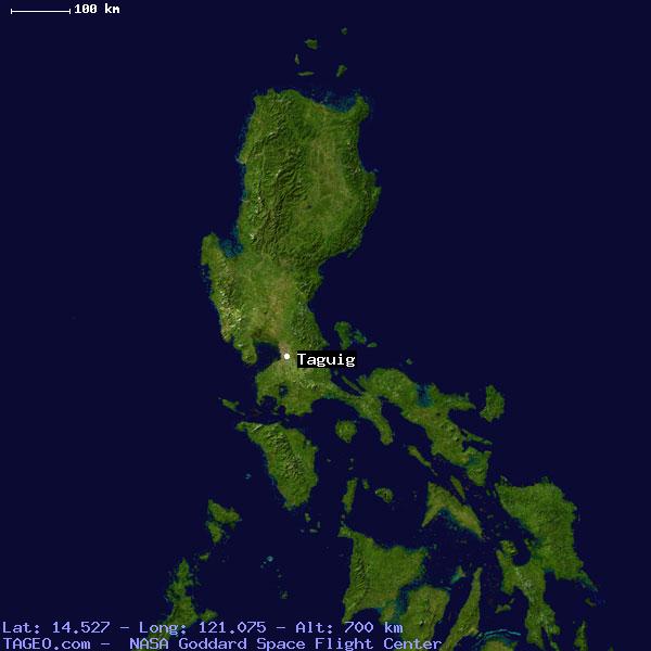
Taguig City, Philippines
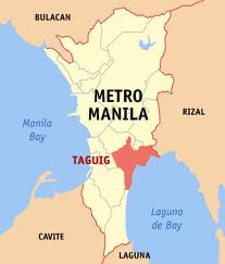
The City of Taguig (Tagalog pronunciation: [ta'ɡiɡ], (Tagalog: Lungsod ng Taguig), is a highly urbanized city located in south-eastern portion of Metro Manila in the Philippines. From a thriving fishing community along the shores of Laguna de Bay, it is now an important residential, commercial and industrial center. The recent construction of the C-5 highway and the acquisition of the Fort Bonifacio development area has paved the way for the cityhood of the municipality. It will also be accessed by the future C-6 Road.
Taguig City lies on the western shore of Laguna de Bay and is bordered by Muntinlupa City to the south, Parañaque to the southwest, Pasay to the west, Cainta and Taytay on the northeast and Makati, Pateros, and Pasig to the north. Taguig River, a tributary of the Pasig River cuts through the northern half of the municipality and Napindan River, also a tributary of the Pasig forms the common border of Taguig with Pasig City.
The city ranked first among Philippine cities in the Ease of Doing Business Index, conducted by the World Bank's International Finance Corporation.
History
Before the Spaniards came, Taguig was a part of the Kingdom of Tondo ruled by Rajah Soliman. There were also accounts that Chinese settlements were once present in the area as revealed by the recent archeological diggings of various artifacts like cups, plates and other utensils, which bear Chinese characters. This was believed to have originated from China's Ming dynasty.
Taguig was one of the earliest known territories to have been Christianized when the Spaniards succeeded in subjugating mainland Luzon through the Legazpi expedition in 1571. Between the years 1582 and 1583, Taguig was of the encomienda of Tondo headed by an Alcalde Mayor, Captain Vergara. It was in 1587 when Taguig was established as a separate "pueblo" (town) of the then province of Manila. Captain Juan Basi was its Kapitan from 1587 to 1588. According to records, Taguig had nine (9) barrios then namely, Bagumbayan, Bambang, Hagonoy, Palingon, Sta. Ana, Tipas, Tuktukan, Ususan, and Wawa. Records show that Tipas had once petitioned to become an independent town but was denied by the Spanish government.
During that time, Taguig was accessible via the Pasig River, which was connected to two large bodies of water, the Manila Bay and Laguna de Bay. The population then was estimated to be 800 tributes. The town produced more than enough rice for their consumption but had less sugar cane to mill. The men lived through fishing while women wove cotton cloth and "sawali" from bamboo strips.
The people of Taguig were known to have resisted both Spanish and American colonial rule. During that early period of Spanish colonition. Don Juan Basi, "Kapitan" of Taguig from 1587 to 1588, attempted to overthrow the Spanish government but failed, being exiled for two years as punishment. When then Katipunan was on its early years, many from Taguig became followers and later joined the uprising. The people of Taguig also joined the revolutionary government of General Emilio Aguinaldo on August 6, 1898.
During the American occupation, they struggled against the forces of General Wheaton under the command of General Pio del Pilar. It was recorded that on February 6, 1898, Filipino forces including Taguig "revolutionarios" dislodged an American position in the hills of Taguig, now a portion of Pateros and Fort Bonifacio. They were defeated eventually by the Americans with superiority in the armaments and training. Taguig finally fell to the contingent of the First Washington Volunteer Infantry led by Col. Wholly.
The defeat of the Filipinos after two years of struggle against the American forces subsequently subjected the Philippines to another system of governance. On August 14, 1898, United States occupied the islands and established a military government with General Wesley Meritt as the First Military Governor. He exercised legislative powers until September 1, 1900.
At the start of American occupation, Taguig was proclaimed as an independent municipality with the promulgation of General Order No. 4 on March 29, 1900. The town was subsequently incorporated to the newly created province of Rizal when the Philippine Commission promulgated Act. No. 137 on June 11, 1901. On October 12, 1903, Taguig, Muntinlupa and Pateros were merged by the virtue of Act. No. 942 with Pateros hosting the seat of the municipal government. The merger did not last long as a month later Muntinlupa was segregated from it and made part of Biñan when Act. No. 1008 was enacted on November 25, 1903. However it was returned to Taguig on March 22, 1905 with the promulgation Act. No. 1308. On February 29, 1908, Taguig was again declared an independent municipality through Executive Order No. 20. Eventually, Pateros separated from Taguig and both became independent municipalities of Rizal province on January 1, 1918.
It was also during the American Colonial Period that the US government acquired a 25.78 kmТВ property of Taguig for military purposes. This large piece of land which had a TCT dated 1902, was turned into a camp and was then known as Fort McKinley (named after the 25th president of U.S. President William McKinley). When the Japanese occupied the Philippines in 1942, Fort McKinley was taken over by the Japanese Imperial Army. They occupied the military camp until the end of the war in 1945.
After the Philippines gained its political independence from the United States on July 4, 1946, the US surrendered the Republic of the Philippines all right of possession, jurisdiction, supervision and control over the Philippine territory except the use of the military bases. On May 14, 1949, Fort William McKinley was turned over to the Philippine government by virtue of the US embassy Note No. 0570.
Fort McKinley was made the permanent headquarters of the Philippine Army in 1957 and was subsequently renamed Fort Bonifacio after the Father of the Philippine Revolution against Spain, Andres Bonifacio.
The town's political subdivision was changed to barangays following the nationwide implementation of the Integrated Reorganization Plan (IRP) in the 1970s when the country was under Martial Law. The IRP has increased its subdivisions into 18 barangays, namely, Bagong Tanyag, Bagumbayan, Bambang, Calzada, Hagonoy, Ibayo-Tipas, Ligid-Tipas, Lower Bicutan, Maharlika, Napindan, Palingon, Signal Village, Sta. Ana, Tuktukan, Upper Bicutan, Ususan, Wawa, and Western Bicutan. In the year 2009, Taguig re-organized and re-arranged there barangays making a total of 28, the 10 added being Central Bicutan, Fort Bonifacio, South Daanghari, North Daanghari, San Miguel, New Lower Bicutan, South Signal,Katuparan, North Signal, Pinagsama and Tanyag. On November 7, 1975, Taguig was carved out from the province of Rizal to form the National Capital Region through Presidential Decree No. 824. Today, Taguig is still one of the seventeen (17) cities and municipalities that make up Metro Manila.
In 1998, a bill was passed in Congress pushing for the cityhood of Taguig. The resulting plebiscite in April showed that the citizens were against cityhood. A recent petition to the Supreme Court sought a recount of the plebiscite and the Supreme Court on February 19, 2004 ordered the Commission on Elections to conduct a recount. The recount showed that the residents did want the municipality of Taguig to become a city (21,105 'yes' and 19,460 'no'). Subsequently, Taguig became a city on December 8, 2004.
In 2008, the Taguig City council enacted City Ordinances Nos. 24-27, 57-61, 67-69, and 78, Series of 2008 which created ten (10) new barangays, carving them out from the initial 18 barangays. Hence, in December 2008, after a successful plebiscite, Taguig was politically subdivided into twenty eight (28) barangays.
Origin of the Name
The original 800 farmer-fishermen settlers of the area were good at threshing rice after harvest. Hence they were referred to as "mga taga-giik," and their settlement as "pook ng mga taga-giik." Spanish friar Fray Alonso de Alvarado, together with conquistador Rey Lopez de Villalobos who crossed Pasig River to reach Taguig in 1571 found "taga-giik" difficult to pronounce, and could only produce the word sounding like "tagui-ig." So many mispronouncements later, "tagui-ig" was shortened to the present day "Taguig."
Government
Like other cities in the Philippines, Taguig City is governed by a Mayor and Vice Mayor who are elected to three-year terms. The Mayor is the executive head and leads the city's departments in executing the city ordinances and improving public services. The current mayor for the 2010–2013 term is Ma. Laarni L. Cayetano, the wife of former congressman and now senator Alan Peter S. Cayetano. She currently holds the youngest and 1st female mayor in the City of Taguig. The city mayor is restricted to three consecutive terms, totaling nine years, although a mayor can be elected again after an interruption of one term. George A. Elias is the city's incumbent vice-mayor. The Vice Mayor heads a legislative council consisting of 18 members: 8 Councilors from the First District, 8 Councilors from the Second District, the President of the Sangguniang Kabataan (Youth Council) Federation, representing the youth sector, and the President of the Association of Barangay Chairmen (ABC) as barangay sectoral representative. The council is in charge of creating the city's policies in the form of Ordinances and Resolutions. Current district representatives of the city are Arnel M. Cerafica, representing the 1st district and Sigfrido R. Tiñga representing the 2nd district, son of former associate justice Dante Tiñga and former mayor of Taguig City from 2001-2010.
Landmarks and recreation
- Fort Bonifacio - The National Headquarters of the Philippine Army and the Marine Bases of the Philippine Navy and Philippine Marine Corps.
- Bonifacio Global City - A marvel on its own, this 440 hectare Global City is based on a Master Plan that has been molded after the functionality of Seoul, the excellent systems of Singapore, the innovation of Vancouver and the Visionary outlook of Paris. It is both a quiet residential paradise with areas designed for international educational tourism and is also the heart of Asian Commerce.
- Food Terminal, Inc. (FTI) - the business center that boasts of over 300 medium scale companies in food manufacturing, electronics, garments and service industries.
- Camp Bagong Diwa - The camp is in Lower Bicutan, it is where NCRPO headquarters, prison complex and drug rehabilitation centers are located.
- Department of Science and Technology - A mini forest and eco-tourism park in Bicutan suitable for camping and bivouac activity. It is the national headquarters of the DOST.
- Taguig Veterans' Museum|Veterans' Museum - A museum where war stories in life-sized tableaus are retold using all forms of art fused with high-end technology.
- The Blue Mosque - A religious center and a socio-civic rendezvous for both Filipino and foreign Muslims in Maharlika Village.
- Bantayog ng Bayani - A fitting tribute to the heroes of Taguig during World War I at Fort Bonifacio.
- Shrine of St. Anne - Built in 1587 in Sta. Ana, one of the Philippines' oldest churches.
- Dambanang Kawayan - A century old church in Tipas made of pure, native bamboo. It was inaugurated as a parish in 1969, comprising barangays Ligid-Tipas, Ibayo-Tipas, Calzada, and Palingon.
- Museo de Sta. Ana - A museum at the Shrine of St. Anne. The repository of artifacts detailing the rich religious culture and history of Taguig since 1857.
- Parola - Built in the 17th century, it stands guard at the mouth of Napindan Channel where the Pasig River crosses into the Laguna Lake. It became the secret rendezvous point of the Katipunan as it planned its moves to achieve Philippine's Independence. The Parola was chosen by KKK Supremo, Gat Andres Bonifacio, as a meeting place because of its strategic location being the most accessible channel from Tondo, Manila and from the Municipios along the Pasig River and the Province of Laguna.


- ЁЄ
- ЁЄ
- ЁЄ
- ЁЄ
- ЁЄ
- ЁЄ
- ЁЄ
- ЁЄ
- ЁЄ
- ЁЄNmjNUuzXqd
- ЁЄNmjNUuzXqd
- ЁЄNmjNUuzXqd
- ЁЄNmjNUuzXqd
- ЁЄNmjNUuzXqd
- ЁЄNmjNUuzXqd


-
МПяМОХЭ :МПя АГВБИ ХзЧьЖѕЗЮ27Бц 8, 10Уў (ПЊЛяЕП, ПЅХИПі)02-3482-0542
-
УЛСжМОХЭ :УцКЯ УЛСжНУ ЛѓДчБИ ЛчСїДыЗЮ 350ЙјБц 11-2, 3Уў(МЙЎЕП)043-221-0543
-
КЮЛъМОХЭ :КЮЛъБЄПЊНУ КЮЛъСјБИ СпОгДыЗЮ 721-1, 5Уў(КЮРќЕП)051-808-0515
-
УЂПјМОХЭ :АцГВ УЂПјНУ МКЛъБИ ДмСЄЗЮ 9, 12Уў (ЛѓГВЕП, ХфХфНККєЕљ)055-282-9345


-
ЛчРЬЦЎ СЂМгРк ХыАш
-
ПРДУ44ОюСІ408
-
ЧбДо33,515ДЉРћ12,187,711
-
РЯРЯУжАэ94,672ШИПјМі20,299