


 ЧЪРкДхФФ ОпАЃЛѓДу ПРЧТ
 11ГтПЌМг МвКёРкИИСЗ 1РЇ
 ГЛАд ИТДТ ОюЧаПј УЃБт
 ИЎОѓ ЧаБГ ЙцЙЎБт
 СжИЛПЁ ГЛАЁ ОЕ КёПыРК?
 УжАэАЁМККё РЬКЅЦЎ СёБтБт
 ЧіСіПЁМЕЕ ЧЪРкДхФФ!
 ЧіСіПЁМ АЁДЩЧб


 ЧЪРк ЦЏБо Ч§ХУ! ФСНУОюСі МКёНК


 АЁСЗПЌМіЗЮ ДйЧдАд ОзЦМКёЦМ

-
МјРЇСІИёСЖШИМі
-
 И№ОЫ КИОЫ Йъ ЗЛЦЎЧЯБт~ ИЎСЖЦЎ ПЙОрБюСі
 88,181
 -
 [ЧЪИЎЧЩ ММКЮ] ФЋИ№ХзНК ПЉЧр 100Йш СёБтБт 38,599
 -
 ИЖДвЖѓ НУГЛ - ИЎРп АјПјСЄКИ. (ЛчСј 16Рх ЦїЧд) 30,134
 -
 ММКЮРЧ СіПЊСЄКИ15,129
 -
 ИЖДвЖѓ БйБГ - ЕћАЁРЬЕћРЬ ПЉЧр СЄКИ13,649
 -
 [ЧЪИЎЧЩ ММКЮ/ИЗХК] ШЃХк МїЙк ПфБн Йз СЄКИ12,662
 -
 КИЖѓФЋРЬРЧ И№Еч И№НРРЛ КММі РжДТ ЛчСјУИ.12,542
 -
 ИЖДвЖѓ БйБГ - ЦХЛѓЧб ЦјЦї ПЉЧрСЄКИ12,094
 -
 [ММКЮ-ЙшМБТјРх] МБЙкШИЛч РќШЙјШЃПЁПф~11,667
 -
 ИЖДвЖѓ СіПЊ(ПЁИЃЙЬХИ -ИЛЖѓХз)РЧ СіЕЕ/ЧбБЙ РННФСЁ/МюЧЮИє11,559


- РЬИЇ : tutors
- РлМКРЯ : 2013-05-02
- СЖШИМі : 3569
- УпУЕМі : 0
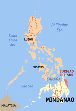
Surigao del Sur is a province of the Philippines located in the CARAGAregion in Mindanao. Its capital is Tandag City and borders Surigao del Norte to the north, Agusan del Norte and Agusan del Sur to the west, and Davao Oriental to the south. Surigao del Sur is located at the eastern coast of Mindanao and faces the Philippine Sea.

GEOGRAPHICAL LOCATION
The Province of Surigao del Sur is the 56th Philippine province and is located in the Northeastern coast of Mindanao facing the Pacific Ocean between 125ТА40' to 126ТА20' East Longitudes and 7ТА55' and 9ТА20' North Latitudes. It is bounded on the Northwest by the Province of Surigao del Norte, on the Southeast by Davao Oriental, on its Eastern side by the Pacific Ocean, and on the West and Southwest by the Provinces of Agusan del Norte and Agusan del Sur. This strategic location enables the province to establish favorable economic linkages with other neighboring provinces. Surigao del Sur has 2 cities and 17 municipalities most of which are located in the coastal areas with Tandag as its capital. These municipalities are subdivided into 314 barangays and has two congressional districts.


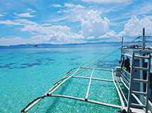
Surfing in Surigao del Sur is widely known and have been one of the local and tourist attractions. This extreme sport can be found in Cantilan and Lanuza. Another sport being played is the skim boarding in which several municipalities has been attracting tourists.
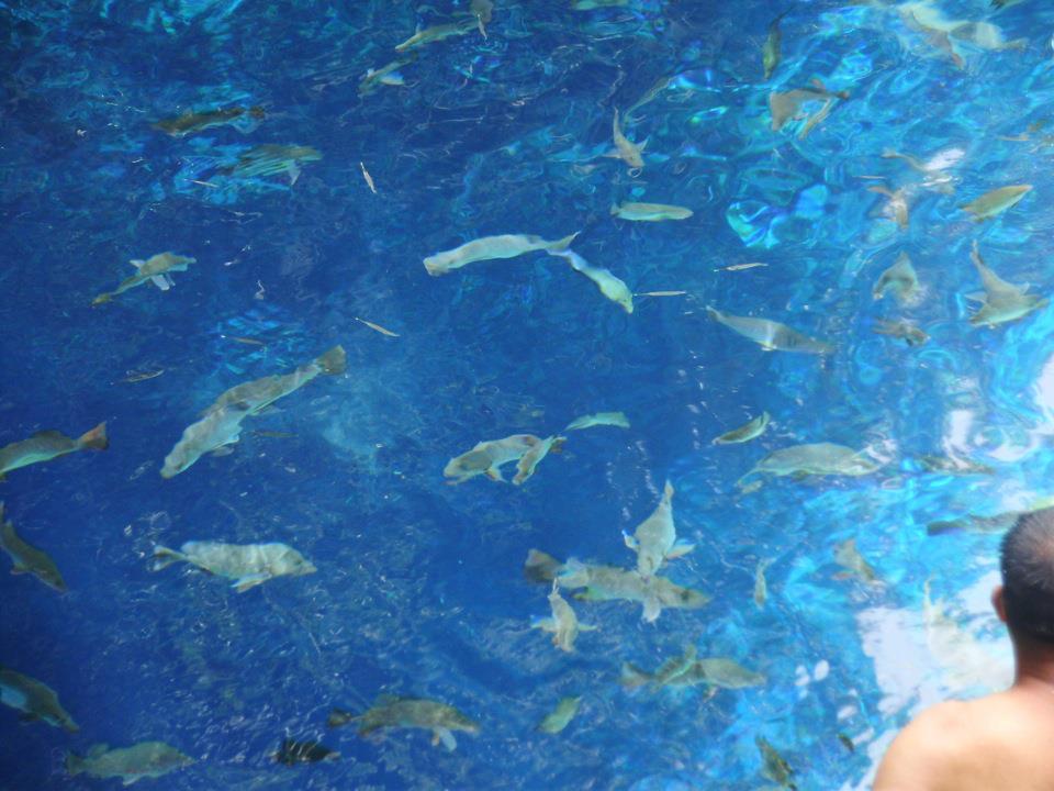

Hinatuan River

Land Area
The land Area of the province is 523,050 hectares or 5,230.50 sq. kilometers representing 27.75 percent of the total land area of Caraga Administrative Region and about 5.14 percent and 1.74 percent of the total land area of Mindanao and Philippines, respectively. It is elongated in shape extending from the northeastern part of Carrascal to the southernmost Municipality of Lingig. It is approximately 300 kilometers in length and 50 kilometers in its widest stretch which runs from Cagwait to San Miguel. Municipal-wise, San Miguel has the biggest land area accounting for 11.08 percent of the total provincial land area while Municipality of Bayabas has the smallest constituting about 0.64 percent only.


- ЁЄ
- ЁЄ
- ЁЄ
- ЁЄ
- ЁЄ
- ЁЄ
- ЁЄ
- ЁЄ
- ЁЄ
- ЁЄNmjNUuzXqd
- ЁЄNmjNUuzXqd
- ЁЄNmjNUuzXqd
- ЁЄNmjNUuzXqd
- ЁЄNmjNUuzXqd
- ЁЄNmjNUuzXqd


-
МПяМОХЭ :МПя АГВБИ ХзЧьЖѕЗЮ27Бц 8, 10Уў (ПЊЛяЕП, ПЅХИПі)02-3482-0542
-
УЛСжМОХЭ :УцКЯ УЛСжНУ ЛѓДчБИ ЛчСїДыЗЮ 350ЙјБц 11-2, 3Уў(МЙЎЕП)043-221-0543
-
КЮЛъМОХЭ :КЮЛъБЄПЊНУ КЮЛъСјБИ СпОгДыЗЮ 721-1, 5Уў(КЮРќЕП)051-808-0515
-
УЂПјМОХЭ :АцГВ УЂПјНУ МКЛъБИ ДмСЄЗЮ 9, 12Уў (ЛѓГВЕП, ХфХфНККєЕљ)055-282-9345


-
ЛчРЬЦЎ СЂМгРк ХыАш
-
ПРДУ72ОюСІ408
-
ЧбДо33,515ДЉРћ12,187,739
-
РЯРЯУжАэ94,672ШИПјМі20,299